
- This event has passed.
Equinox Marathon
September 18, 2021 @ 12:00 am
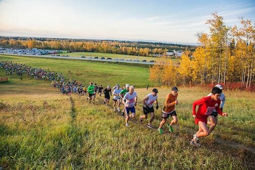
The only thing that constitutes a ‘city’ in interior Alaska, Fairbanks often feels more like a crossroads than a conventional metropolis. But at the nexus of some truly epic routes – north to the Arctic, east to Canada and south to Denali – the mix of people in this once-rough-and-ready gold-rush town is rarely boring. Stay long enough and you’ll meet the cross-continental cyclist who’s pedaled up from Tierra del Fuego, the disorientated cruisers bussed in from Seward, the Arctic-bound adventurers stocking up on supplies in Fred Meyer, and the bush pilots heading out to Kobuk, Chalkyitsik or some other chilly Arctic landing strip.The Equinox Marathon is an annual marathon held in Fairbanks, Alaska near the time of the autumnal equinox. It is one of the most difficult marathon courses in the world and includes 3285 ft. (1001 m) of elevation gain (and loss).
Course Highlights
The Equinox Marathon starts, and ends, on the soccer field close to the Student Rec Center and the Patty Center Gym on the University of Alaska Fairbanks campus.
The course quickly climbs approximately 200 feet to Yukon Drive, where runners and hikers take a right turn and proceed on Yukon Drive to Kuskokwim Drive and another slight hill climb before heading downhill on Kuskokwim Drive and turning into the woods … at this point you are ¾ of a mile into the course. The course runs on trails for approximately ¾ of a mile until you head out onto the bike path next to Ballaine Lake … only to quickly turn back into the woods and follow trails along a rolling course that eventually takes the participants out to the intersection of Yankovich Road and Ballaine Road {approx. Mile 2.4 of the course}. Runners are only on Ballaine Road for 2/10 of a mile before they turn back into the woods and onto trails that cross Kittiwake Drive and then Sandpiper Drive. Mile 3 is just before coming out to Ballaine Road again. The course follows Ballaine Road. for approx. .3 mile then heads back onto the trail and begins a gentle climb as it crosses Sparrow Court, continuing on a rolling trail to Kittiwake Drive and Mile 4 of the course. The course has runners crossing Dalton Trail before heading into single track trail across of what is now Magoffin Highlands, a subdivision with a trail easement that extends to the east boundary of the Musk Ox Farm (aka Large Animal Research Station — LARS).
Participants head south along the fence of the Musk Ox Farm to Mile 5 before turning west and then south as they cross Yankovich Road and back onto trail, which is mostly single track and known for its roots and ruts.
This single track trail comes out of the woods to cross the intersection of Miller Hill and Yankovich Roads and head west along the power line easement. The trail then runs north along Lawlor Road, passing Mile 6 and headed up a slight climb before descending down a dirt road and taking a left heading west along more single track trail.
Mile 7 of the course is at Hafele Avenue, and then the course heads to Line Drive, where in about the distance of a ¼ mile, runners head west along Black Sheep Road, and in another ¼ of a mile, turn right on the bike path along Sheep Creek Road. Participants cross Sheep Creek Road and the railroad tracks at Mile 8 of the course, and head toward Ester Dome Road.
The bottom of Ester Dome Road is at approximately 8.4 mile of the course, and the location of Relay Exchange Zone One. From here, runners and walkers begin their 1,800 foot climb up to Ester Dome, heading past St. Patrick Road at Mile 9, and on to Mile 9.7, where the trail heads back into the woods. The trail continues up Ester Dome to Mile 11.3, where it meets up with Ester Dome Road again {just before the intersection of North Henderson Road}. At this point, the course stays on Ester Dome Road as runners pass Mile 12, approximately .4 mile before the Ullerhaven parking area.
The infamous “out & back” begins here as the, a 4 ½ mile stretch of the course that features rolling hills and lots of rock and ruts, and some single track that proves to be especially challenging as the two-way traffic requires one of the participants to step off the trail so the other one can pass {usually the faster runner has the right of way}. Mile 13 and 13.1, the half-way point on the course are along a gravel section of road. Awesome views of Mt. Denali {aka Mt. McKinley} are sometimes there to greet runners, and sometimes not as you may be running in the clouds. Some challenging two-track, rough, gravel, rock road, climbs and descent are ahead to the turn around which occurs on a downhill section. Very demoralizing to be headed downhill, picking your way for footing among the rocks only to have to come to a stop, turn around and start climbing back up. A redeeming factor is the aid station. From here it’s back the way you came and a good opportunity to see all those who are chasing you.
The famous “chute” begins at Mile 17.1 of the course {this is also the beginning of Relay Leg Three, as Exchange Zone Two is just past Mile 17}. The steep descent that one encounters on the chute should be approached with caution. This portion of the trail features many rocks and ruts …. the good news is that it is only 1/3 of a mile long, although while you are going down the chute it may seem more like 3 miles long.
At Mile 17.4, the course turns into the woods, and proceeds easterly along some very nice double-wide trail and the participants are able to move fairly fast along mostly downhill terrain through a section of beautiful Birch forest. The course comes out on Henderson Road at Mile 19.4 and heads down Henderson Road, picking up the paved portion of Henderson Road just past Mile 20 of the course. The pavement portion is downhill and much time can be made up here if one does not cramp up and end up leaning on mailboxes to get rid of the cramps.
At Mile 21 ½ , the course turns off Henderson Road and onto Goldhill Road, headed easterly for about ½ mile before turning north onto Cloudberry Drive and then almost immediately turning east onto a powerline easement, that goes on for about a mile. After coming out to GoldHill Road, there is a slight uphill for 200 yards before passing the Mile 23 sign. The course runs along Goldhill Road and a gentle downhill (but at this point it almost feels uphill) past Mile 24 until it dead ends into the Sheep Creek Road Extension.
The course then heads east along the Sheep Creek Road Extension briefly until you make a left turn and onto the UAF trail system and back to the UAF campus. At this point you are at approximately Mile 24.9 of the course, but it’s not quite time to celebrate the finish yet. The course takes another turn uphill, and continues climbing for another ½ mile, before taking a few turns and heading out onto Kantishna Drive. From here it’s ½ mile descent along the road (you can smell the finish) toward Mile 26, onto the soccer field and the sprint to the finish line, a precise 26.2188 miles and 42.195 kilometers.