
- This event has passed.
Navarino Challenge
October 17, 2021 @ 12:00 am
The annual sports celebration, Navarino Challenge, returns in Costa Navarino & Pylos and for the 9th year this fall on October 15-17!Aiming to unite people of all ages and abilities once again through its central message “sports unite people”, the renowned as the second “Best in Wellness” event in the world will promote the benefits of exercise and raise awareness on the Mediterranean diet, towards the fight against childhood obesity.
Navarino Challenge will encourage the youth to engage in kids’ activities through the Active Kids initiative.
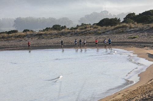
Runners may choose between the Greek Half Marathon (21.1km), 10km, and 5km (running & power walking) routes. Starting from the Navarino Dunes of Costa Navarino, professional and amateur athletes will run along the picturesque coast to Pylos, crossing the beautiful Voidokilia beach, tracing history beneath their feet in King Nestor’s land. They will follow the trail mapped out in the Homeric era by Telemachus, Ulysses’ son, trying to find his missing father.
The Greek Half Marathon is the only trail run that combines soil, sand and asphalt.
10km and 5km routes combine soil and asphalt.
On the same day, the children’s 1km course will take place.
More info: www.navarinochallenge.com
Course Highlights
Half Marathon Route (21.1 km)
This year, just like the previous ones, the routes of Navarino Challenge are renewed and more “challenging” than ever! The route of the Half Marathon starts inside the facilities of Costa Navarino at the bicycle rental area (Navarino Outdoors) and is directed towards the south exit of the complex following the asphalt road slightly uphill for about 500 meters. After exiting the complex, the route turns sharply right into a dirt road towards the beach and downhill. After a distance of running by the sea, it diverges from the beach and follows an uphill track up to 2.5km. It continues on asphalt with slight downhill for 200 meters while the next kilometer (from 3.2km. up to 4.2km.) is the most uphill track of the route. The next kilometer is downhill till the wildlife shelter of Lake Divariou where following the dirt road, we end up at Voidokilia beach where the most beautiful but also demanding part of the route begins.
At this point the route goes around the beach by the sea on the golden sand for 650 m. At the end of the beach it moves left towards the dunes to be driven on a narrow dirt road for about one kilometer around Lake Divariou. Then it diverges from the lake, following a wide dirt road till the pumping station where meets the lake again, to continue moving around within the wetland from the 9th km. up to 13th km. where again meets Voidokilia beach. Having now entered the way back, we move to the mainland on a dirt road in rural area until Petrohori located at the 17th km. Then a short but fairly steep uphill road follows until we enter the last 4km. which are the same as in the beginning of the route with the respective small uphill and downhill till the finishing line in Costa Navarino!
Technical characteristics of the route:
Start – stop elevation: 6m.
Maximum height: 33 m.
Minimum altitude: 0 m.
Route ground: 40% asphalt road, 56% dirt road, sand 4%.
Power stations : 2,1 km., 3,5 km., 5 km., 7,7 km., 10 km., 12.5 km., 15.3 km., 17.4 km., 18.9 km., Finish line.
All stations will have fresh water, while at the stations in the 5th, 10th and 15.3km. there will be energy drinks and / or gel.
10km Route
The route of 10 km. is also renewed, by giving participants the opportunity this year to run in the unique beauty of Voidokilia beach. The 10km. route again this year has small differences in height and consists of approximately 50% dirt road and 50% of asphalt road. The 10km route starts inside the facilities of Costa Navarino at the bicycle rental area (Navarino Outdoors) and is directed towards the south exit of the complex following the asphalt road slightly uphill for about 500 meters. After exiting the complex, the route turns sharply right into a dirt road towards the beach and downhill. After a distance of running by the sea, it diverges from the beach and follows an uphill track up to 2.1km. (Power Station) where it turns right into a narrow path for 100 meters. A steep dirt road follows up to 3rd km. which is the most “difficult” part of the route. From the 3rd km. up to the 4th km. the road is downhill and asphalt. From the 4th km. until the 6th km. is the most beautiful part of the route as it is located in Voidokilia region. The ground is dirt road and runs parallel to the wildlife shelter of Lake Divariou which ends at Voidokilia beach. At this point the route follows the golden sand by the sea for about 300 meters and the road back begins.
The first part of the way back is a dirt road without any particular inclination and then it diverges from the lake and follows an uphill part from the 6th km. until the 7th km. which is the most “difficult” part of the return. Afterwards the corresponding downhill follows from the 7th km. up to the 9th km. Then we have the last slight uphill part of the route and we reach the finishing line.
Technical characteristics of the route:
Start – stop elevation: 6m
Maximum height: 33 m.
Minimum altitude: 0 m.
Route ground: 50% asphalt road, 47% dirt road, 3% sand.
Power stations: 2.1km., 4km., 6km., 7,9km., Finish line.
5,4km Route
The shortest route of the event is 5,4 km., which is quite easy and with small height differences and moves about 80% on dirt road and 20% on asphalt.
The route starts inside the facilities of Costa Navarino at the bicycle rental area (Navarino Outdoors). It starts slightly uphill and is directed towards the south exit of the complex following the asphalt road slightly uphill for about 400 meters.
After the complex, the route turns sharply right into a dirt road towards the beach. In this point the route is slightly downhill.
After a distance of running by the sea, it diverges from the beach and follows an uphill track until 2,4 Km which is the most “difficult” part of the route.
Then the route continues with a downhill towards the beach, passing by the Water Station (at 3.1km.) until 4,6 km.
From this point an uphill part starts for 400 meter and the last 400 meters of the route are slightly downhill.
Technical characteristics of the route:
Race Distance: 5.385μ.
Start – stop elevation: 6 m.
Maximum altitude: 24 m.
Minimum elevation: 2m.
Route Ground: 80% dirt road, 20% asphalt road.
Water stations: 3.1km., Finish line.