

- This event has passed.
Mountain Lakes 100
September 17, 2021 @ 12:00 am
One of the country’s most beautiful 100 mile races starts at Olallie Lake and runs along more than 25 mountain lakes. This race features the best trail running Oregon has to offer – technical and rocky sections, views of mountain peaks in every direction, and 60 miles of luscious sections of the Pacific Crest Trail. Course has 87.8 miles of single-track trails, 9 miles of gravel roads, 3 miles of jeep roads and 25 miles of pavement.
Course Highlights
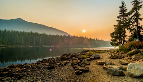
Start to Mile 5.3 (Aid Station 1)
The course starts at Olallie Lake Cabins at the north end of beautiful Olallie Lake and heads south along Olallie Lake before connecting to steep jeep roads and the PCT. After a short section of the PCT, runners will arrive at Breitenbush Lake Campground.
Mile 5.3 to Mile 11.4 (Aid Station 2)
The route will follow a long, steady down hill (from 5,500 ft. to 3,600 ft.) with expansive views before leveling off on FS Road 380.
Mile 11.4 to Mile 20.8 (Aid Station 3)
The course heads north before connecting with Trail 719 to start the climb up toward Olallie Lake. Semi-technical trails wind their way past multiple small lakes and up to 5,500 ft. before connecting with the PCT and heading south to the Breitenbush Lake Campground.
Mile 20.8 to Mile 26.1 (Aid Station 4)
The course heads north along the PCT, then reconnects to the jeep roads along Olallie Lake providing clear views of Olallie Lake and Olallie Butte.
Mile 26.1 to Mile 29.2 (Aid Station 5)
Continuing north along the PCT, the course skirts Olallie Butte before arriving at Olallie Meadows.
Mile 29.2 to Mile 36.7 (Aid Station 6)
This section of the course is the most remote and has some nice downhills, mixed with some rocky sections.
Mile 36.7 to Mile 43.9 (Aid Station 7)
After a ~700ft climb and skirting North Pinhead Butte, descend ~1000ft to Warm Springs Aid Station.
Mile 43.9 to Mile 49.4 (Aid Station 8)
Drop an additional ~500 ft, crossing the Warm Springs River. Then ascend ~900ft. The climb is long, relatively speaking. It is rather rough in sections so watch your footing. The trail eventually flattens out, passing clear cuts on the east side. You then drop slightly to the aid station, on the north side of power lines.
Mile 49.4 to Mile 54.7 (Aid Station 9)
The trail drops over this section a total of ~850ft. It is gradually but noticeable. One could definitely make up time on this section if your legs have some reserves in them (but save them for the return trip to the finish!). You will hear cheers as you near the aid station from volunteers and crew.
Mile 54.7 to Mile 71.0 (Aid Station 10, 11, 12)
After dropping down to lake level, this section of the course stays close to the lake before returning to Aid Station 12. Although this section is quite flat, there are several quick ups and downs with short technical sections that can be trickier than expected.
Mile 71.0 to Finish (Aid Station 13, 14, 15, 16 to Finish)
From here, it’s a straight return on the PCT to the finish!